











PARIS — South Korean Earth observation specialist Satrec Initiative is deepening its collaboration with parent company Hanwha Aerospace to develop and field a next-generation space architecture, combining ultra-high-resolution optical imagery with a massive commercial synthetic-aperture-radar constellation.
Speaking at the World Space Business Week conference in Paris, Eugene Kim, executive vice president of Satrec Initiative, outlined the company’s ambitious roadmap to manufacture and launch a fleet of four advanced satellites capable of capturing 10-centimeter-class optical imagery. This new capability is designed to seamlessly integrate with Hanwha’s broader strategic vision, which centers on a 64-satellite synthetic-aperture-radar (SAR) constellation announced earlier this year in July.

The sprawling SAR constellation is engineered to deliver high-frequency revisit rates, achieving a 30-minute global revisit capability by 2031. By pairing these radar eyes with ultra-high-resolution electro-optical sensors, Satrec Initiative and Hanwha aim to capture a dominant market position in defense, intelligence, and commercial Earth observation sectors.

"Together with ultra-high-resolution SAR and ultra-high-resolution electro-optical, the constellation is expected to open up new opportunities to provide Satellite as a Service in the defense and intelligence field," Kim told SpaceNews during the conference.

Beyond raw image acquisition, the companies are emphasizing downstream utility. Customers will gain direct access to sophisticated, artificial intelligence-based satellite imagery analysis provided by SI Analytics, a specialized spinoff of Satrec Initiative. According to Kim, this integration is designed to deliver timely, accurate, and actionable intelligence to military and commercial clients alike who require rapid decision-making tools in fast-evolving environments.
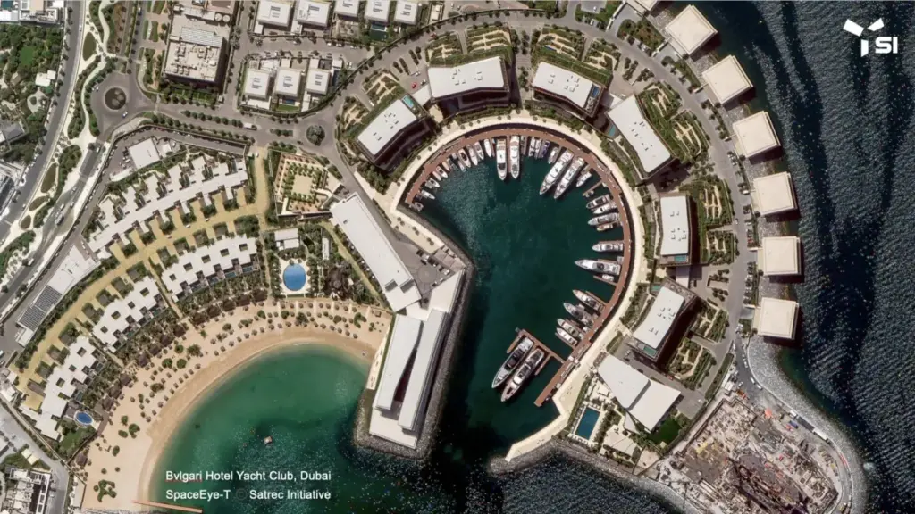
The push toward 10-centimeter-class resolution reflects a broader industry-wide race as market leaders continuously strive to sharpen their observational capabilities from space. Satrec Initiative already operates the SpaceEye-T satellite, launched in 2025, which successfully acquires 25-centimeter optical imagery and has recently attracted European customer interest through lease agreements with SI Imaging Services. However, with global competitors aggressively scaling up their optical clarity, Satrec Initiative is making decisive moves to stay ahead of the curve.

Major international aerospace players are similarly ramping up their technical specifications. Airbus is actively developing its Pléiades Neo Next satellites, slated to gather 20-centimeter imagery by 2028. Concurrently, Vantor is planning to capture 20-centimeter-class imagery utilizing its upcoming Vantage smallsat constellation, while ImageSat International announced ambitious plans to deploy Earth imagery capabilities boasting 25-centimeter native resolution.
Achieving the targeted 10-centimeter-class resolution, however, requires overcoming severe engineering hurdles. To pull off this unprecedented level of optical detail, Hanwha’s upcoming satellites are designed to operate not in traditional orbits, but in very low Earth orbit (VLEO), maintaining altitudes well below 400 kilometers.

Operating at such low altitudes introduces intense environmental challenges. Spacecraft flying in VLEO experience severe atmospheric drag and heavy exposure to atomic-oxygen, both of which accelerate material wear, degrade surfaces, and threaten orbital stability over time.
To mitigate these risks and gather crucial flight data, Hanwha announced in a July release that it plans to take a methodical, incremental approach. The company will begin by launching a test satellite near an altitude of 500 kilometers. Once orbital performance and operational data are validated, Hanwha will gradually lower the spacecraft’s orbit to collect the necessary empirical data required to protect and optimize future operational craft operating in VLEO.